Website under construction / Proposal for BTWEA Scheme. Not currently trading or accepting commercial clients.
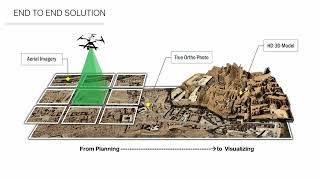
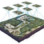 DRONE SURVEYING – Surveying with a drone offers enormous potential to GIS professionals. With a drone, it is possible to carry out topographic surveys of the same quality as the highly accurate measurements collected by traditional methods, but in a fraction of the time.
Drone surveying uses unmanned aerial vehicles (drones) equipped with high-resolution cameras to collect accurate and detailed data for various industries. It offers benefits such as precise measurements, time and cost savings, increased safety, enhanced visualizations, and environmental monitoring. My professional drone surveying services provide reliable results for aerial mapping, site inspections, and environmental assessments. Contact us for more information.
Drone surveying is a modern and innovative approach to surveying and data collection that uses unmanned aerial vehicles (UAVs), also known as drones. By utilizing advanced technology and high-resolution cameras, drone surveying offers numerous benefits and advantages over traditional surveying methods.
1. High-precision data: Drones equipped with high-resolution cameras can capture accurate and detailed images, allowing for precise measurements and mapping. This enables professionals in various industries, such as construction, agriculture, and infrastructure development, to obtain accurate data for their projects.
2. Time and cost savings: Drone surveying significantly reduces the time and cost associated with manual surveys. Drones can cover large areas in a fraction of the time it would take using traditional surveying methods. This efficiency translates into cost savings for businesses and organizations.
3. Increased safety: By using drones for surveying, you eliminate the need for personnel to work in hazardous or hard-to-reach areas. This not only improves safety but also reduces the risk of accidents and injuries common in traditional surveying methods.
4. Enhanced visualizations: Drone surveying allows for the creation of 3D models, orthomosaics, and topographic maps. These visual representations provide a better understanding of the surveyed area, enabling stakeholders to make informed decisions for their projects.